Structure and dynamics of the Southeast Indian Ridge and off-axis volcanism, 129°E to 140°E: Preliminary results of the STORM cruise
Anne BRIAIS1 and the STORM cruise scientific party: F. Barrere1, C. Boulart2, G. Ceuleneer1, N. Ferreira3, B. Hanan4, C. Hémond3, S. Macleod5, M. Maia3, A. Maillard1, S. Merkuryev6, S.H. Park7, S. Révillon3, E. Ruellan1, A. Schohn3, S. Watson8, and Y.S. Yang7.
1CNRS, Geosciences Environment Toulouse, University of Toulouse, France
2IFREMER, Centre de Brest, Plouzané, France
3CNRS, Domaines Océaniques, Institut Universitaire Européen de la Mer, Plouzané, France
4San Diego State University, San Diego, USA
5University of Sydney, Australia
6IZMIRAN, St Petersburg, Russia
7Korea Polar Research Institute, Incheon, South Korea
8IMAS, University of Tasmania, Hobart, Australia
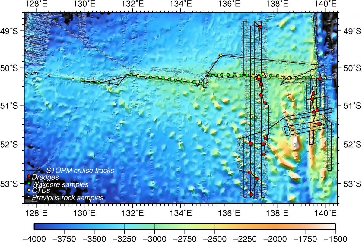
We present recent observations of the South-East Indian Ridge (SEIR) between 129 and 140°E collected during the STORM cruise (South Tasmania Ocean Ridge and Mantle) on the N/O L'Atalante in early 2015. The SEIR between Australia and Antarctica displays large variations of axial morphology and discontinuities despite an almost constant intermediate spreading rate. The Australia-Antarctic Discordance (AAD), between 120°E and 128°E, is a unique section of the mid-ocean ridge where the magma budget is abnormally low, and which marks the boundary between Indian and Pacific mantle domains with distinct geochemical isotopic compositions. The STORM project focuses on the area east of the discordance from 128 to 140°E, where gravity highs observed on satellite-derived maps of the flanks of the Southeast Indian Ridge between Tasmania and Antarctica reveal numerous volcanic seamounts. A major objective of the STORM cruise was to test the hypothesis of a mantle flow from the Pacific to the Indian domains. We collected multibeam bathymetry and magnetic data between 136 and 138°E to map off-axis volcanic ridges up to crustal age of 10 Ma, we mapped the SEIR ridge axis between 129°E and 140°E, as well as the northern part of the George V transform fault. We collected rock samples on seamounts and in the transform fault, basaltic glass samples along the ridge axis, and near-bottom samples and in-situ measurements in the water column. Our observations reveal that the off-axis seamounts form near the SEIR axis, and are not associated to off-axis deformation of the ocean floor. They show a general shallowing of the ridge axis from the AAD to the George V TF and the presence of robust axial segments near the transform fault. They allow us to describe the evolution of the north of the complex transform fault system. They also permit to locate new hydrothermal systems along the ridge axis.


